


Menhirs in Alpine Regions and the Hochwechsel
- Christa Berger
- Mar 11, 2023
- 9 min read

Updated: Mar 25
In the Alpine and pre-Alpine regions of Central Europe, there is a significant collection of megalithic stone monuments and underground structures, some constructed using dry stone techniques. Unlike the prehistoric stone monuments of Western and Northern Europe, these sites have received little scientific study.


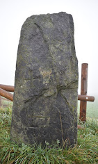
Various menhirs with and without perforations in Joglland: Most menhirs stand freely in the landscape, mark property boundaries, or are positioned at courtyards like guardians. While many of these stones have perforations, not all do.

Very often, perforated stones are found next to monuments in fields or near churches. In Wenigzell, one perforated stone is embedded in the church wall and another in the outer church wall, which, in my opinion, suggests a demarcating function as a spiritual boundary. A similar example can be found in Birkfeld, where a stone is placed in the narrowest part of the church.
Megalithic Monuments: Perforated Stones and Menhirs
Over the last 20 years, knowledge of prehistoric stone settings in Europe has expanded significantly. In Austria alone, there are well over 1,000 menhirs and perforated stones across the federal states of Carinthia, Tyrol, Vorarlberg, Salzburg, Upper Austria, Lower Austria, Burgenland, and Styria. Notably, a large number of these structures are located at higher altitudes in the Alpine region. More than 40 stone settings have been discovered in western Styria, particularly in the Koralpe and Gleinalpe areas. As of the latest research in 2023, a total of 570 such stone settings have been documented and mapped in northeastern Styria, specifically in the Joglland region.


The Vorau open-air museum demonstrates how these stones have often been put to practical use, being incorporated into fence gates or serving as doorsteps for old buildings, such as stables. In Joglland, these stones are commonly referred to as "Torstein," meaning "gate stones."
Megalithic Monuments: Underground Systems
Especially in the area around Vorau, where well over 1,000 archaeological sites above and below ground have been discovered to date, hundreds of open underground structures have been examined, with some undergoing scientific analysis. A particularly striking feature of the more than 50 dry stone walls in and around Vorau is the corbelled vault construction of the ceilings, which are covered with carefully placed heavy stone slabs. This architectural style does not align with medieval or modern construction, as those periods primarily used semicircular vaulted arches.
This type of construction can be found in Styria in the so-called "shelters" of presumed prehistoric mountain settlements, as well as in the collapsed and restored entrance areas of Erdstall tunnels and underground rock passages. The cover slabs of the underground structures in the Vorau region have been provisionally dated using TCN (Terrestrial Cosmogenic Nuclide) dating to a minimum age of 10,000 to 12,000 years before present. This timeframe aligns internationally with the megalithic cultural remains of Göbekli Tepe in Eastern Anatolia (Turkey).


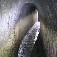


So-called Erdställe, meaning underground sites, can be found in various forms and designs in the Vorau area.
At this point, special thanks go to Dr. H. Kusch and his wife, who have initiated and advanced research in this field over the past decades.


From left to right: Left – Holed stone and menhir deposits north of Hartberg (graphic by Peter Holl and Heinrich Kusch); Center – Distribution of underground facilities in Joglland (source: Heinrich Kusch); Right – For comparison: Distribution map of Erdställe in Bavaria (source: Bavarian State Office for the Preservation of Monuments).
The local population of Joglland has been aware of the 790 rock passages, Erdstall tunnels, and underground stone structures for centuries. During times of war, these spaces served as hiding places for people, small livestock, food, and valuables.
Similar subterranean tunnels are also believed to exist in southern Styria, reportedly extending from Riegersburg to the surrounding farmsteads.


According to old stories, several tunnels are said to lead from Riegersburg to the surrounding farmsteads. The Riegersburg stands proudly atop a 482-meter-high volcanic rock, dominating the landscape. The castle was first mentioned in historical records in 1138 as "Ruotkerspurch", meaning the castle of a nobleman named Rüdiger. However, archaeological evidence suggests that the basalt cone, rising over 100 meters, was inhabited as early as 6,000 years ago. During the Carantanian period (from the 7th century), a refuge existed on the castle hill, strategically protected on three sides by steep rock faces. This is reflected in the name of the valley west of the castle and the stream that flows through it. Throughout its history, Riegersburg has served as a defensive stronghold against enemy incursions from the east and, remarkably, has never been conquered. (1st picture: FB dieriegersburg; 2nd picture: Riegersburg seen from Schöckl, photo: FB Schöckl).
Position of the Stone Settings and Corridors
The elevated position of the Erdstall tunnels and stone settings is primarily influenced by the topography of the Vorau Basin, where these corridors are located between 600 and 800 meters above sea level, corresponding to the altitude of the local settlements in this region.
Historical maps reveal that during the Josephine land survey of Inner Austria (1784–1785), the extent of human settlement was significantly higher than today. Farmsteads and cottager buildings were situated at altitudes of up to 1,200 meters above sea level, slightly below the elevations where alpine pastures were already being used for summer grazing.
For example, the small pasture belonging to my family, where heifers are brought up each year, lies at approximately 1,200 meters. The Vorauer Schwaig (pasture) is located at 1,511 meters above sea level. At similar elevations on the Wechsel, remnants of old dry stone walls can still be found today.

Map excerpt from the Josephine state survey - Inner Austria (1784-1785) - Wechsel area
Bavaria and Central Europe
Not only in Austria but also in Bavaria, numerous Erdstall tunnels can be found. There, they are also known as Schratzllöcher (Schratzl = dwarf, Löcher = caves). The main distribution area extends from the Bavarian Forest to Slovakia. These tunnels, constructed using mining techniques, are typically found beneath old farmsteads and, in some cases, under churches and cemeteries, closely resembling those in Joglland.
The exact reasons for their regional abandonment in the 14th and 15th centuries remain unclear. However, this period coincides with efforts to maintain peace and the associated decline of feuding in the late Middle Ages, which may have influenced their disuse.
In Austria as well, Erdstall tunnels were largely sealed at the end of the Middle Ages, often accompanied by burials or the deliberate washing in of sand. The Erdstall tunnels of Bavaria and Joglland exhibit striking similarities in construction and layout. Common features include horizontal and vertical passageways, walls, (sitting) niches, as well as light niches and ventilation shafts.

Plan and Sections of the Erdstall in Petersberg, Kissing Figure from: Illing, Johann: Description and Recording of the Underground Passages in Kissing, Royal District Court of Friedberg, with 1 lithographic plate, Munich 1854, p. 13. (Source: Bavarian State Library, Bavar. 4085,43)
In Bavaria, most Erdstall tunnels have been discovered in the Bavarian Forest, particularly in the district of Cham. Numerous systems are also known in the southern Upper Palatinate Forest, though their distribution in the Upper Palatinate rarely extends west beyond the Naab River. Further west, the Franconian Jura marks a natural boundary, where natural caves replace these artificial underground structures. Isolated examples have been documented in Mainfranken and Oberfranken, while hardly any are known west of the Lech in Swabia. In recent years, an increasing number of discoveries have been recorded in the Upper Bavarian region.
Outside of Bavaria, Erdstall tunnels have also been found in Baden-Württemberg, Saxony-Anhalt, and Saxony. Similar underground systems exist in Central Europe, including Poland, the Czech Republic (South Moravia), Slovakia, Hungary, and France.
Torsteine at the Own Yard
Since Joglland is my birthplace, I can share that there was once a mysterious passage leading away from the ancient stone cellar on my parents' farm. Unfortunately, it is now buried. I would also like to add that in many old farmhouses, and in some cases still today, there was an access point to these underground corridors located beneath the large table in the living room (the so-called Jogl table), which connected the farms to one another.


Left and center: So-called Jogltische (Jogl tables) in the Vorau open-air museum; right: an old example.
In addition, two menhirs mark the boundaries of my parents' square courtyard—one positioned due north and the other due east. The corners of the courtyard align precisely with the cardinal directions: north, south, east, and west. As children, we imagined these stones as our guardians.
One of them stands right next to an ancient and massive linden tree, whose treetop spans over 40 meters in full leaf during summer. Our grandmother used to say that this tree had already witnessed Charlemagne and the Turks. Its enormous above-ground roots and sprawling branches, which served as swings, were our favorite playground—just as they had been for my mother and grandfather. Many old farmsteads in Joglland still have centuries-old linden trees, typically standing no more than 15 meters from the main residential building. The purpose behind it is to ward off lightning. As a protective tree, the linden tree was often the center of village life; people gathered under it, danced and celebrated, and even held court. The linden tree was also often planted at wayside crosses in the fields, where it was supposed to provide protection during thunderstorms. It was believed that lightning never strikes the linden tree. Farmers would plant a linden tree in their yard to protect their house, stables, and barns from fire and lightning. The linden tree is also said to protect against witches and evil spirits, and in later times, it was planted at monasteries, churches, and chapels as a cult tree for prayer. Christianity adopted the Germanic veneration of the linden tree and applied it to the service of the Virgin Mary. With its heart-shaped leaves, it is also the tree of love. The soft wood is well suited for carving, and its fresh or dried flowers are used to make tea.


Left to right: Chapel with two flanking linden trees; View of the treetops of our farmyard linden tree almost defoliated in November; View on our linden tree: the yellow structure in the upper part of the tree on the left is honeycomb from wild bees that live in it
The linden tree blooms at a time when meadows are often no longer in bloom. Nectar is also scarce in many gardens for bees and bumblebees. The late blooming of the linden tree is therefore of great importance to them.
Old Hollow Ways, Dry Stone Walls at Higher Altitudes and Strange Rock Formations on the Hochwechsel
A tunnel system in this area (Joglland) is said to run from Masenberg to Hochwechsel (distance about 40 km as the crow flies).

The Wechsel massif with Hoch- and Niederwechsel seen from the Masenberg.
There are old stories about these underground passages, said to extend from the Masenberg—believed to be hollow inside and to contain a hidden lake—all the way to the Hochwechsel. According to legend, the corridors are illuminated by the treasures within. This is how my uncle told it to me when I was a child. However, there is no evidence to support these claims.
Hollow Ways


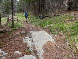
Many old hollow ways lead to the Hochwechsel, cutting deep into the terrain due to centuries of use. Pictures 4 and 5 show the ascent to the Wechsel via the Steinerne Stiege (Stone Staircase), a path that appears to be very old. Figure 6 depicts the so-called Roman Road, where vehicle tracks carved into the rock have a track width of about one meter.
In the past, these hollow ways were primarily used in winter to transport wood from the highland forests. The heavy and often dangerous loads were brought down to the valley by sledge and then transported further via rivers. These ancient paths also served as routes for driving cattle down from the pastures. To this day, the Wechsel region maintains a vibrant alpine economy with many beautiful Schwaigen (alpine pastures). As a child, I witnessed the autumn cattle drive every year, a tradition that continues to this day.
Dry Stone Walls
Old dry stone wall remains, but also intact ones of unknown age can be found from about 700 meters up to about 1,400 meters above sea level, here on picture 1 near the Hilmtor, picture 2 south of the Niederwechsel (both in spring). Image 3 was taken near the Kring in Vorau. Since the lowlands were once marshy and mossy, the settlements were higher than today.


Rock Formations at Niederwechsel and Hochwechsel: The Crystalline Origins of the Wechsel Massif
The Wechsel was formed from a crystalline structure, making its rock unique within the Alps. It developed under immense pressure in a very cold environment, resulting in its distinctive geological composition.
The crystalline basement of the Wechsel belongs to the Lower Eastern Alpine Wechsel Unit. It is characterized by alternating gneiss, distinguished by pea-sized albite crystals, which give it a recognizable appearance. The primary mineral components—albite, quartz, muscovite, and chlorite—classify the rock petrographically as sericite-chlorite-albite gneiss.
On the eastern edge of the Alps, several geological zones converge within a relatively small area. The Wechsel Massif and the Bucklige Welt are part of the Central Alps, which stretch across Austria. These regions are composed of crystalline rocks, including slate and gneiss, which shape their gently rolling and rounded landscapes.
The Wechsel’s unique formation sets it apart as an exceptional geological feature within the Alpine region.


Hike to the Hochkogel at Wechsel in November
On the 1,669 meter high Niederwechsel there are interesting rock and stone formations whose older use or origin is not known. These stones are scattered along a ridge for over a kilometer, extending down to the tree line, where they merge into the Steinerne Stiege, which itself stretches for several kilometers.


Rocks and stones at Niederwechsel; View from Nieder- to Hochwechsel; Aerial view of the Wechselplateau; Sunset on way back home.
Sources
W. Brandi (1933): Zur Geomorphologie des Masenbergstockes am Nordostsporn der Alpen. Mit einer Kartenskizze (Beilage I). In: Mitteilungen des naturwissenschaftlichen Vereins für Steiermark.
Further Reading
Archaeological Investigation of the Kandelhofer/Kandlhofer Erdstall near Puchegg, Styria, Austria.
Heinrich & Ingrid Kusch (2009): Tore zur Unterwelt. 4th edition, Graz.
Heinrich & Ingrid Kusch (2014): Versiegelte Unterwelt. 1st edition, Graz.
Preliminary Archaeological and Historical Verification of Megalithic Stone Settings and Underground Dry Stone Structures in Northeastern Styria, Austria.

Comments